Drones as Tools For Wildlife Research
Drones have become an incredibly popular tool for wildlife biologists. The most popular reasons for the increased use is that drones can collect huge amounts of data across a great spatial extent, all while doing so in a relatively non-invasive matter. For these reasons, drone technology is extremely attractive to researchers working in remote regions such as the Arctic and sub-Arctic. My research using drones involves investigating predator-prey behaviour using drone videos, understanding behavioural responses of wildlife to drones, and mapping of snow goose habitat damage in coastal Hudson Bay lowlands with drone imagery.
Wildlife Responses to Drone Surveys
|
One of the earliest concerns of using drones for wildlife research was the potential disturbance effects of these tools on individuals. We have used cameras during drone flights to observe snow geese, eiders, and polar bears, and have demonstrated relatively little behavioural impacts of drones on these species. Most recently, we have used heart rate monitors to quantify potential stress response of eiders during drone surveys, showing that drones do not impact eider heart rates either!
|
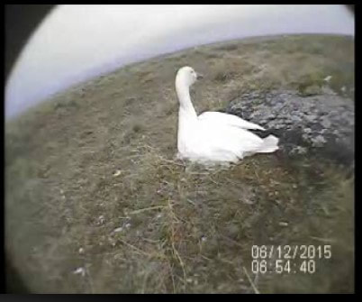
Image from a video camera placed on a snow goose nest to observe the females behaviour during drone surveys
|
Mapping Habitat Degradation by Lesser Snow Geese
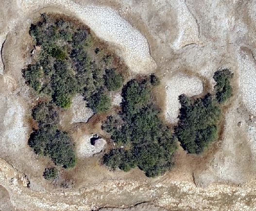
RGB Drone imagery of habitat degradation at 75m above ground. Note surrounding light gray regions: this is dried out, hypersaline ground cause by a lack vegetation cover.
|
The mid-continent snow goose population has increased dramatically over the past 40 years, leading to increased pressure on vegetation communities. Mapping degradation on foot is laborious, time consuming, and especially difficult in remote regions where snow geese spend their summers. Drones can help by collecting data over a greater spatial extent than is currently possible on the ground. Perhaps more importantly, this also allows us to create a permanent digital archive of landscape, which can be used for future analyses.
|
Relevant Publications
Barnas, A.F., Geldart, E.A., Love, O., Jagielski, P.M., Harris, C., Gilchrist, G., Hennin, H.L., Richardson, E.S., Dey, C.J., and C.A.D. Semeniuk. 2022. Predatory cue use in flush responses of a colonial nesting seabird during polar bear foraging. Animal Behaviour. 193: 75-90 www.sciencedirect.com/science/article/abs/pii/S0003347222002329
Geldart, E.A., Barnas, A.F., Semeniuk. C.A.D., Gilchrist, G., Harris, C.M., and O. Love. A colonial-nesting seabird shows no heart rate response to drone-based population surveys. Scientific Reports. 12 (1): 1-10 www.nature.com/articles/s41598-022-22492-7
Jagielski, P.M., Barnas, A.F., Gilchrist, G., Richardson, E., Love, O., and C.A.D. Semeniuk. 2022. The utility of drones for studying polar bear behaviour in the Canadian Arctic: opportunities and recommendations. Drone Systems and Applications. 10 (1): 97-110 cdnsciencepub.com/doi/pdf/10.1139/dsa-2021-0018
Barnas, A.F., Chabot, D., Hodgson, A., Johnston, D.W., Bird, D.M., and S.N. Ellis-Felege. 2020. A standardized protocol for reporting methods when using drones for wildlife research. Journal of Unmanned Vehicle Systems . 8(2): 89- 98 https://doi.org/10.1139/juvs-2019-0011
Barnas, A.F., Darby, B.J., Vandeberg, G.S., Rockwell, R.F., and S.N. Ellis-Felege. A comparison of drone imagery and ground-based methods for estimating the extent of habitat destruction by lesser snow geese (Anser caerulescens caerulescens) in La Pérouse Bay. PLoS ONE. 14(8) https://doi.org/10.1371/journal.pone.0217049
Barnas, A.F., Felege, C.J., Rockwell, R.F., and S.N. Ellis-Felege. 2018. A pilot(less) study on the use of an unmanned aircraft system for studying polar bears. Polar Biology. 41: 1055-1062 https://doi.org/10.1007/s00300-018-2270-0
Barnas, A.F., Newman, R., Felege, C.J., Corcoran, M.P., Hervey, S.D., Stechmann, T.J., Rockwell, R.F., and S.N. Ellis-Felege. 2018. Evaluating behavioral responses of nesting lesser snow geese to unmanned aircraft surveys. Ecology and Evolution. 8: 1328-1338 https://doi.org/10.1002/ece3.3731 PDF
